File:Aantal treffers GIS op internet zonder extra info.PNG
From Wikimedia Commons, the free media repository
Jump to navigation
Jump to search

Size of this preview: 628 × 599 pixels. Other resolutions: 252 × 240 pixels | 503 × 480 pixels | 805 × 768 pixels | 1,073 × 1,024 pixels | 1,374 × 1,311 pixels.
Original file (1,374 × 1,311 pixels, file size: 655 KB, MIME type: image/png)
File information
Structured data
Captions
Captions
Add a one-line explanation of what this file represents
Summary[edit]

|
This text image could be re-created using vector graphics as an SVG file. This has several advantages; see Commons:Media for cleanup for more information. If an SVG form of this image is available, please upload it and afterwards replace this template with
{{vector version available|new image name}}.
It is recommended to name the SVG file “Aantal treffers GIS op internet zonder extra info.svg”—then the template Vector version available (or Vva) does not need the new image name parameter. |
| DescriptionAantal treffers GIS op internet zonder extra info.PNG |
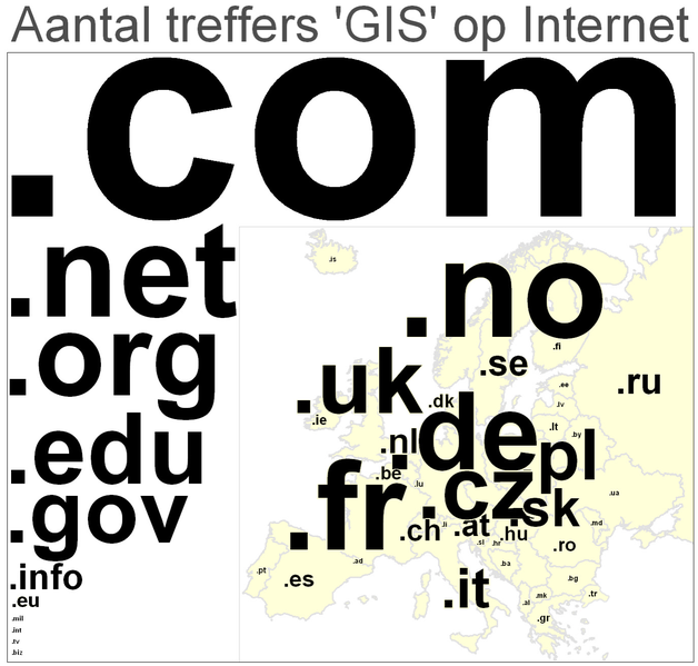
Nederlands: Aantal treffers 'GIS' op internet. (Het aantal treffers op 'GIS' via Google is weergegeven voor alle generieke (links) en Europese topleveldomeinnamen (rechts in de kaart). De tekstgrootte van elke domeinnaam is evenredig met het aantal treffers. Bron: Google dd 30-1-2008. Alleen voor Frankrijk is niet 'GIS' geteld maar SIG, de Franse vertaling van GIS. Merk op de onverwacht grote aantallen hits in Tsjechië, Slowakije, Polen en Noorwegen. Wellicht zijn zogenaamde mirrorsites hier de oorzaak van, of worden treffers dubbel geteld. Het aantal GIS-hits dat niets met geografische informatie systemen te maken heeft vertroebelt wellicht de verhoudingen, echter, een vluchtige blik over de hits lijkt dit niet te bevestigen. |
| Date | |
| Source | Eigen media. Het aantal hits is gemeten op Google dd 30-1-2008 |
| Author | T.Nijeholt at nl.wikibooks |
| Other versions |
 |
Licensing[edit]
T.Nijeholt at nl.wikibooks, the copyright holder of this work, hereby publishes it under the following licenses:

|
Permission is granted to copy, distribute and/or modify this document under the terms of the GNU Free Documentation License, Version 1.2 or any later version published by the Free Software Foundation; with no Invariant Sections, no Front-Cover Texts, and no Back-Cover Texts. A copy of the license is included in the section entitled GNU Free Documentation License.http://www.gnu.org/copyleft/fdl.htmlGFDLGNU Free Documentation Licensetruetrue |
| This file is licensed under the Creative Commons Attribution-Share Alike 3.0 Unported license. | ||
| Attribution: T.Nijeholt at nl.wikibooks | ||
| ||
| This licensing tag was added to this file as part of the GFDL licensing update.http://creativecommons.org/licenses/by-sa/3.0/CC BY-SA 3.0Creative Commons Attribution-Share Alike 3.0truetrue |
This file is licensed under the Creative Commons Attribution-Share Alike 2.5 Generic license.
Attribution: T.Nijeholt at nl.wikibooks
- You are free:
- to share – to copy, distribute and transmit the work
- to remix – to adapt the work
- Under the following conditions:
- attribution – You must give appropriate credit, provide a link to the license, and indicate if changes were made. You may do so in any reasonable manner, but not in any way that suggests the licensor endorses you or your use.
- share alike – If you remix, transform, or build upon the material, you must distribute your contributions under the same or compatible license as the original.
You may select the license of your choice.
Original upload log[edit]
The original description page was here. All following user names refer to nl.wikibooks.
- 2008-01-31 20:02 Nijeholt 1375×1311× (136813 bytes) {{Information |Description=Aantal treffers 'GIS' op internet. (Het aantal treffers op 'GIS' via Google is weergegeven voor alle generieke (links) en Europese topleveldomeinnamen (rechts in de kaart). De tekstgrootte van elke domeinnaam is evenredig met h
- 2008-01-31 19:55 Nijeholt 1375×1311× (136267 bytes) {{Information |Description=Aantal treffers 'GIS' op internet. (Het aantal treffers op 'GIS' via Google is weergegeven voor alle generieke (links) en Europese topleveldomeinnamen (rechts in de kaart). De tekstgrootte van elke domeinnaam is evenredig met h
File history
Click on a date/time to view the file as it appeared at that time.
| Date/Time | Thumbnail | Dimensions | User | Comment | |
|---|---|---|---|---|---|
| current | 12:25, 6 December 2022 |  | 1,374 × 1,311 (655 KB) | Iktsokh (talk | contribs) | Added Turkey (East Thrace) |
| 15:10, 25 February 2009 |  | 1,375 × 1,311 (134 KB) | BotMultichill (talk | contribs) | {{BotMoveToCommons|nl.wikibooks|year={{subst:CURRENTYEAR}}|month={{subst:CURRENTMONTHNAME}}|day={{subst:CURRENTDAY}}}} {{Information |Description={{nl|Aantal treffers 'GIS' op internet. (Het aantal treffers op 'GIS' via Google is weergegeven voor alle g |
You cannot overwrite this file.
File usage on Commons
The following 6 pages use this file:
File usage on other wikis
The following other wikis use this file:
- Usage on ar.wikipedia.org
- Usage on arz.wikipedia.org
- Usage on az.wikipedia.org
- Usage on be-tarask.wikipedia.org
- Usage on diq.wikipedia.org
- Usage on fa.wikipedia.org
- Usage on fi.wiktionary.org
- Usage on gl.wikipedia.org
- Usage on he.wikipedia.org
View more global usage of this file.
Metadata
This file contains additional information such as Exif metadata which may have been added by the digital camera, scanner, or software program used to create or digitize it. If the file has been modified from its original state, some details such as the timestamp may not fully reflect those of the original file. The timestamp is only as accurate as the clock in the camera, and it may be completely wrong.
| Horizontal resolution | 37.79 dpc |
|---|---|
| Vertical resolution | 37.79 dpc |